


In which geographies are land use sectors a net sink of carbon dioxide, and in which are they a net source? How do land use emissions compare to those in energy-related sectors? How have these emissions changed, and how might they evolve? Analysts and policy makers can begin answering these questions with our expanded ClimateWorks Tracker, which allows users to make geographic and sectoral comparisons across several dozen climate indicators using data from ClimateWorks’ Carbon Transparency Initiative (CTI). New to the economy-wide modeling tool are data on land use emissions, along with modeling of Brazil’s greenhouse gas (GHG) emissions, a capability developed through our partnership with the System for Greenhouse Gas Emissions and Removals Estimates (SEEG), a platform developed by a consortium of Brazilian NGOs under the umbrella of the Brazilian Climate Observatory. These additions, available on a newly released Portuguese language version of Tracker as well as on our English and simplified Chinese versions, are shedding light on critical components of Earth’s climate system: forests and the ways that land use is affecting their climate-regulating services.
Forests are an indispensable component of the climate system, mediating inter-annual fluxes in carbon dioxide concentrations and sequestering mammoth quantities of carbon in their trees, grasses and soils. As deforestation and degradation of natural landscapes impair these functions, the need to understand forests’ contribution as net carbon sinks and how that contribution is changing becomes more urgent. The new additions to the ClimateWorks Tracker address the lack of transparency and complexity in the presentation of scientific assessments of the effects of forests, land use, and land use change on the net balance of GHG emissions. By enabling comparisons of land use emissions with projections, pledges, and scenarios, the Tracker promotes civil society’s ability to hold governments accountable with regard to these effects on the design, implementation and monitoring of public policies.
One geography where those emissions play an outsized role is Brazil, home of the world’s largest rainforest. Brazil was the first large forested country on the planet to systematically monitor rainforest cover loss. Since the 1980s, the country’s use of satellite image analysis has guided the design and monitoring of public policies to reduce deforestation in the Amazon. Many lessons learned are now being implemented in other biomes in Brazil and shared with other forested countries in Latin America, Asia and Africa through South-South cooperation initiatives.
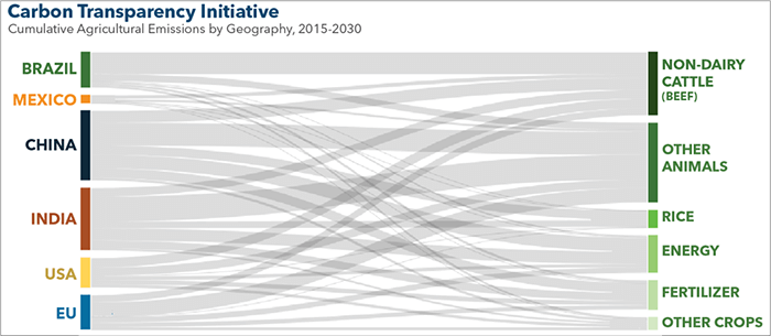
Through partnerships with multiple Brazilian NGOs under the SEEG consortium, we teamed up with national and international experts and created an all-new CTI model of Brazil’s greenhouse gas emissions. Relying on local official data sources, this model elucidates the activity and intensity metrics that drive GHG emissions in Brazil on a yearly basis. We will use this information to track decarbonization progress, as with our models of other geographies, and we have integrated the results into the previously published Regions, Sectors, and Metrics dashboards on the ClimateWorks Tracker website to allow comparisons of key climate indicators for Brazil with other CTI geographies, including China, the EU, India, Mexico, and the US.
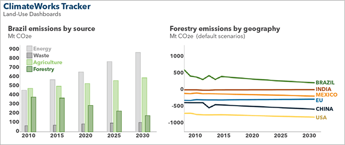
Brazil’s Paris Agreement commitment to reduce GHG emissions highlights the opportunity the country has to make a significant contribution to the global goal of limiting temperature increases to well below 2°C. Endowed with abundant low-carbon energy resources and vast expanses of forests, Brazil is nevertheless haunted by the possibility of a surge in fossil fuel use and the undoing of hard-fought victories on progress halting deforestation. However, by fulfilling its Nationally Determined Contribution (NDC) presented in Paris and the goals from its National Policy of Climate Change, Brazil could ensure that its land use change and forests GHG emissions would become net negative by 2030.
It is the duty of civil society organizations to support NDC pledges, in part by speaking forcefully against deforestation trends, and integral to that effort are open and transparent data and tracking services. The updated ClimateWorks Tracker now not only provides those services with regard to land use but also contextualizes land use emissions and sinks relative to those in the energy-related sectors.
As mid-century and other longer-term emissions reduction strategies emerge, the focus on these carbon fluxes will intensify as nations strive to reach net-zero carbon emissions. Development of the Brazil model offered an excellent opportunity to collaborate with local land use experts engaged on the fluxes (including Imaflora and Imazon). We have since rolled out similar methodologies for all other CTI geographies and have made results available in a newly designed Land Use Dashboard. With other local partners, including the Climate and Land Use Alliance (CLUA), we will next use the CTI models to explore how the agricultural sector could contribute to reducing emissions associated with livestock and crop production.